|
|||||||||||||||||||||||||||||||||||||||||||||||||||||||||||||||||||||||||||||
 |
|||||||||||||||||||||||||||||||||||||||||||||||||||||||||||||||||||||||||||||
|
|
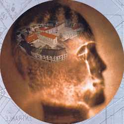
VisionSoftware / About Graphicomp / VisionGraphicomp NV was established as a multi disciplinary software home in 1982. Graphicomp is specialised in the development of high-minded 2D/3D CAD/GIS software for architectural, engineering, town planning, visualization en animation purposes. As well as the head office in Maldegem Graphicomp also has a German branch in Cologne and sells her products over resellers and distributors. The 2D/3D CAD/GIS software ICAADS is being applied succesfully considerable time at several offices in German cities. Graphicomp looks back upon more than 10 years of experience in the sphere of programming for different German ministries as well. For town planning technical services too, special software has been developed. Zoning plans and land register plans, architectonic studies for town centre modernizations, façade studies and renovations, designs for shopping streets or pedestrian streets are not only being drawn with the computer in the second dimension but also planned and visualized in the third dimension. The application of the third dimension to elucidate the design in whichever perspective was until recently very time-consuming. Usually only expensive, labour-intensive and unalterable project presentations (scale-models) were made after terminating the design. Territorial plans, sections and views, perspective drawing and photorealistic images can now, thanks to the use of the ICAADS 2D/3D CAD/GIS system, be realized in less than no time already during the draft phase.
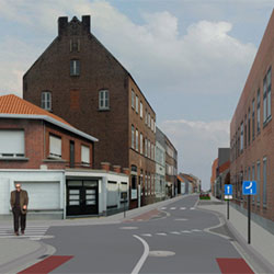
Parts of a digital urban territorial plan can be read in through an interface:
pictures of existing surrounding areas and aereal photographs Scanned plans or drafts can be used as background on the screen. The technical progress, the increasing automation and the increased efficiency and quality requirements oblige the designer to work out projects accurate and competently and at the same time present these to everyone involved in the project. Thanks to the newest developments within the ICAADS software, areas on land register and zoning plans can be reclassified and reassessed. Financial calculations can likewise be carried out. ICAADS offers everyone who participates in the project totally new possibilities. Plans can be assessed better and justified decisions can be taken. Projects can be demonstrated in colour prints, photographs, CDs, DVDs, overhead sheets and faithful videos. The most actual form of project presentations is the presentation through the internet. That way the civilians are being brought nearer. |
|||||||||||||||||||||||||||||||||||||||||||||||||||||||||||||||||||||||||||
Graphicomp nv - Krommewege 31B - B-9990 Maldegem - T. 32(0)50/71 93 28 - F. 32(0)50/71 54 19 - info@graphicomp.com |
|||||||||||||||||||||||||||||||||||||||||||||||||||||||||||||||||||||||||||||
Graphicomp nv - c/o debelux-Handelskammer - Friedrichstrasse 42-44 - D-50676 Köln - T. 49(0)221 139 02 95 - F. 49(0)221 139 02 96 |
|||||||||||||||||||||||||||||||||||||||||||||||||||||||||||||||||||||||||||||